I woke up early, walked to the gas station, on main where I buy my coffee. I like The Buzzard Nest Inn. It just doesn't have coffee. I had to leave as early as I can so I can clean my clothes. I just didn't feel like it while I was staying in Lamar.
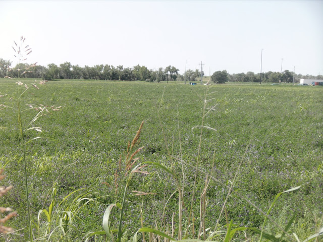
It IS a beautiful day. But most days are this way, it just that I feel so good when I am moving. Always have. In this part of HWY 50, they only have hay and corn. But the hay is vetch. Vetch grows in southern Alabama in the winter and it gets too hot in late spring. Seeing those little blue flower was a little surprising to me.
In southeastern Colorado they cut and bale round and square bales. The round bales aren't as big as the 2500 lb. round bales here in southern Alabama. Now, the square bales (target weight 1000 lbs) are a lot bigger than the 65 lb bales they bale in southern Alabama.
With clean clothes and only smoking weed left, I got on my way. I didn't even walk a mile when I got a ride with a couple. With the way, I talk they knew that I didn't belong in their neck of the woods. So, they invited me to come to their house and smoke what they called Hashish. It was totally all-some.
He heated a piece of brass that was connected to a thing-a-ma-gig that you smoked from. After he heated the metal, he would use a pocket knife and scrape a little and put it in the heated metal. You got a hell-of-a-hit.
I didn't stay long it was the time of day that was cooler than what I used to. So I got my sandwiches and continued walking.
In no time at all, two guys my age, pulled over and gave me a ride to Granada. But it was after 12:00 when we arrived, Indian Museum was closed for lunch. Now my money is getting low and so is my weed. I ate at the Shop and Go convenience store. While I was waiting for them to open I charged up my camera and phone (I use the phone for a rechargeable clock.)
He never got back there. Off to Bristol, I go. Hwy 350
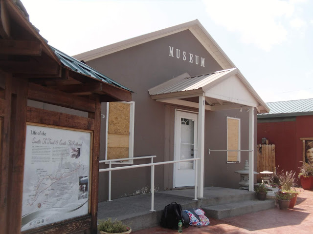
They had a hail storm and the windows are boarded up. The person that opens the place never came back from lunch
Welcome to Prowers County As the Santa Fe Trail brought commerce and trade that opened the western United States, Highway 287 and 50 bring commerce from all corners of our great country to Southeastern Colorado. Prowers County is at the crossroads growing successful commerce today while fortifying the hope of tomorrow.
While You Are Here Visit:
The Colorado Welcome Center in Lamar - Camp Amache west of Granada - Midwest Farms State Fishing Area east of Granada - Big Timbers Museum north of Lamar - Bent's New Fort west of Lamar - Spreading Antlers Golf Course south of Lamar - AND all of the fine Shops, Motels, and Restaurants in Holly, Granada, Wiley and Lamar
We Hope you enjoy your visit and come back soon
1822
The Republic of Mexico was established after Mexican revolutionaries overthrew Spanish control of New Spain, thus opening commerce to all traders. Two-way traffic launched the Santa Fe Trail, with American traders moving west from towns along the Missouri River, and Mexican traders moving north and east out of Santa Fe.
1833-1849
Bent's Fort thrived as a part of a network of secure trading posts that trapped the area's natural resources. As the beaver trade declined in the late 1820's and ended in the 1830's, trappers moved onto the prairies to hunt buffalo.
1848
Following the Mexican American War and the Treaty of Guadalupe-Hildago, Mexico surrendered lands that today include Nevada and Utah, and portions of Colorado, California, Arizona, and New Mexico. This began a 20-year period of transition that lead to permanent Hispanic and Anglo American occupation of Southeastern Colorado.
1860's
The Santa Fe Trail was a viable route until the buffalo trade declined, coinciding with the construction of railroads.
1873
The Atchison, Topeka and Santa Fe Railroad laid 10 miles of rail from the Kansas Border into Colorado.
1876
The standard gauge tracks of the Atchison, Topeka and Santa Fe expanded along the Arkansas River to Pueblo, Meeting the narrow gauge tracks of the Denver Rio Grande.
1878
A race between the two railroads to claim a route over Taton Pass culminates in a lantern-lit coup by the Santa Fe engineers.
1880
The Santa Fe Railroad reaches the City of Santa Fe, and the Santa Fe Trail became an artifact of the past.
www.secoloradoheritage.com
Travel the Pathways Through Time
Pre-History: Comanche National Grassland
These are the early lands of Indian nations - Comanche and Kiowa south of the Arkansas River, Cheyenne and Arapaho North of the River. The short-grass prairie and rocky canyons supported the vast herds of buffalo, thus were essential to the tribe's survival
1833-1849: Bent's Old Fort On the Santa Fe Trail
From 1833-1849, Bent's Old Fort flourished on the Santa Fe Trail, and early trade route for domestic and international commerce. The Fort was a place that brought together in relative peace people of Native American, Mexican and European descent.
1853-1860: Bent's New Fort
In 1853, William Bent built a new fort, 40 miles east of the old fort, hoping to continue his trading empire. However, in 1860, the new fort was leased by the US Army a commissary for Fort Lyon and ultimately served as the staging point for the Sand Creek Massacre.
1864: Sand Creek Masacre
675 U.S. troops under the command of Colonel John M. Chivington, departed Fort Lyon on November 28, 1864, to launch a surprise attack on about 70 Cheyenne and Arapaho camped along Big Sandy Creek. About 200 Native Americans were killed in the dawn assault.
1863-1873: Boggsville
Two couples established sheep and cattle industries which marked the beginnings of an agricultural lifestyle that is now the lifeblood of the Canyons and Plains region. Rumalda Luna Boggs and her husband Thomas raised sheep. Amache Prowers, daughter of Ochinee, a Cheyenne Chief who died at Sand Creek, married John Prowers, and Anglo who worked for the Indian agent at Fort Lyon. They raised cattle.
1942-1945: Camp Amache
Amache Prowers' influence was evident years later in the naming of Camp Amache, the "relocation camp" in Granada that held over 7,000 Japanese and Japanese Americans from 1942-1945 during World War II. Out of this camp, built on fear in a time of war, came grace, pride, and unsurpassed patriotism.
We have a number of motels to choose from.
Holly
Miles Court 716 west Colorado
Holly Inn Suites 128 south main street
Lamar
Rodeway Inn Cow Palace - 1301 north main street
Days Inn - 1302 north main street
Holiday Inn Express - 1304 north main street
Buzzard's Nest - 113 north main street
Lamar Inn - 1201 north main street
Holiday Motel - 404 north main street
Super 8 Motel - 1202 north main street
3RD Street Nest B&B - 304 south 3rd street
Chex Inn - 1210 south main street
Blue Spruce Motel - 1801 south main street
The Lodge at Country Acres - 29151 HWY 287 south
Looking for an R.V. Park?
Check out:
Country Acres - 29151 HWY 287 south of Lamar of
Sportsman's Campground and Horse Motel - 5285 HWY 50 northwest of Lamar
This project funded by prowers county lodging tax revenue.
Granada State Champions
2009 Baseball
2006 Football
1996 Girls Basketball
1991 Baseball 1995
1989 Basketball 1991
1979 Football 1988
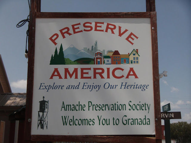
The sign is made of wood and displayed on the west side of town.
It IS a beautiful day. But most days are this way, it just that I feel so good when I am moving. Always have. In this part of HWY 50, they only have hay and corn. But the hay is vetch. Vetch grows in southern Alabama in the winter and it gets too hot in late spring. Seeing those little blue flower was a little surprising to me.
In southeastern Colorado they cut and bale round and square bales. The round bales aren't as big as the 2500 lb. round bales here in southern Alabama. Now, the square bales (target weight 1000 lbs) are a lot bigger than the 65 lb bales they bale in southern Alabama.
With clean clothes and only smoking weed left, I got on my way. I didn't even walk a mile when I got a ride with a couple. With the way, I talk they knew that I didn't belong in their neck of the woods. So, they invited me to come to their house and smoke what they called Hashish. It was totally all-some.
He heated a piece of brass that was connected to a thing-a-ma-gig that you smoked from. After he heated the metal, he would use a pocket knife and scrape a little and put it in the heated metal. You got a hell-of-a-hit.
I didn't stay long it was the time of day that was cooler than what I used to. So I got my sandwiches and continued walking.
In no time at all, two guys my age, pulled over and gave me a ride to Granada. But it was after 12:00 when we arrived, Indian Museum was closed for lunch. Now my money is getting low and so is my weed. I ate at the Shop and Go convenience store. While I was waiting for them to open I charged up my camera and phone (I use the phone for a rechargeable clock.)
He never got back there. Off to Bristol, I go. Hwy 350
They had a hail storm and the windows are boarded up. The person that opens the place never came back from lunch
Informational and Historical Images
Welcome to Prowers County As the Santa Fe Trail brought commerce and trade that opened the western United States, Highway 287 and 50 bring commerce from all corners of our great country to Southeastern Colorado. Prowers County is at the crossroads growing successful commerce today while fortifying the hope of tomorrow.
While You Are Here Visit:
The Colorado Welcome Center in Lamar - Camp Amache west of Granada - Midwest Farms State Fishing Area east of Granada - Big Timbers Museum north of Lamar - Bent's New Fort west of Lamar - Spreading Antlers Golf Course south of Lamar - AND all of the fine Shops, Motels, and Restaurants in Holly, Granada, Wiley and Lamar
We Hope you enjoy your visit and come back soon
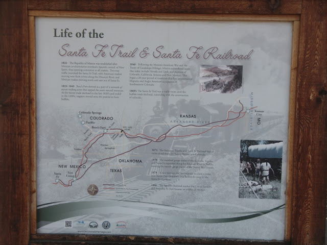
Life of the Santa Fe Trail and Santa Fe Railroad
1822
The Republic of Mexico was established after Mexican revolutionaries overthrew Spanish control of New Spain, thus opening commerce to all traders. Two-way traffic launched the Santa Fe Trail, with American traders moving west from towns along the Missouri River, and Mexican traders moving north and east out of Santa Fe.
1833-1849
Bent's Fort thrived as a part of a network of secure trading posts that trapped the area's natural resources. As the beaver trade declined in the late 1820's and ended in the 1830's, trappers moved onto the prairies to hunt buffalo.
1848
Following the Mexican American War and the Treaty of Guadalupe-Hildago, Mexico surrendered lands that today include Nevada and Utah, and portions of Colorado, California, Arizona, and New Mexico. This began a 20-year period of transition that lead to permanent Hispanic and Anglo American occupation of Southeastern Colorado.
1860's
The Santa Fe Trail was a viable route until the buffalo trade declined, coinciding with the construction of railroads.
1873
The Atchison, Topeka and Santa Fe Railroad laid 10 miles of rail from the Kansas Border into Colorado.
1876
The standard gauge tracks of the Atchison, Topeka and Santa Fe expanded along the Arkansas River to Pueblo, Meeting the narrow gauge tracks of the Denver Rio Grande.
1878
A race between the two railroads to claim a route over Taton Pass culminates in a lantern-lit coup by the Santa Fe engineers.
1880
The Santa Fe Railroad reaches the City of Santa Fe, and the Santa Fe Trail became an artifact of the past.
www.secoloradoheritage.com
Travel the Pathways Through Time
Historic Sites, Canyons, and Plains
Pre-History: Comanche National Grassland
These are the early lands of Indian nations - Comanche and Kiowa south of the Arkansas River, Cheyenne and Arapaho North of the River. The short-grass prairie and rocky canyons supported the vast herds of buffalo, thus were essential to the tribe's survival
1833-1849: Bent's Old Fort On the Santa Fe Trail
From 1833-1849, Bent's Old Fort flourished on the Santa Fe Trail, and early trade route for domestic and international commerce. The Fort was a place that brought together in relative peace people of Native American, Mexican and European descent.
1853-1860: Bent's New Fort
In 1853, William Bent built a new fort, 40 miles east of the old fort, hoping to continue his trading empire. However, in 1860, the new fort was leased by the US Army a commissary for Fort Lyon and ultimately served as the staging point for the Sand Creek Massacre.
1864: Sand Creek Masacre
675 U.S. troops under the command of Colonel John M. Chivington, departed Fort Lyon on November 28, 1864, to launch a surprise attack on about 70 Cheyenne and Arapaho camped along Big Sandy Creek. About 200 Native Americans were killed in the dawn assault.
1863-1873: Boggsville
Two couples established sheep and cattle industries which marked the beginnings of an agricultural lifestyle that is now the lifeblood of the Canyons and Plains region. Rumalda Luna Boggs and her husband Thomas raised sheep. Amache Prowers, daughter of Ochinee, a Cheyenne Chief who died at Sand Creek, married John Prowers, and Anglo who worked for the Indian agent at Fort Lyon. They raised cattle.
1942-1945: Camp Amache
Amache Prowers' influence was evident years later in the naming of Camp Amache, the "relocation camp" in Granada that held over 7,000 Japanese and Japanese Americans from 1942-1945 during World War II. Out of this camp, built on fear in a time of war, came grace, pride, and unsurpassed patriotism.
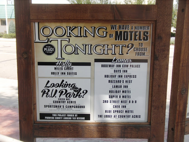
Looking for a Place to Stay Tonight?
We have a number of motels to choose from.
Holly
Miles Court 716 west Colorado
Holly Inn Suites 128 south main street
Lamar
Rodeway Inn Cow Palace - 1301 north main street
Days Inn - 1302 north main street
Holiday Inn Express - 1304 north main street
Buzzard's Nest - 113 north main street
Lamar Inn - 1201 north main street
Holiday Motel - 404 north main street
Super 8 Motel - 1202 north main street
3RD Street Nest B&B - 304 south 3rd street
Chex Inn - 1210 south main street
Blue Spruce Motel - 1801 south main street
The Lodge at Country Acres - 29151 HWY 287 south
Looking for an R.V. Park?
Check out:
Country Acres - 29151 HWY 287 south of Lamar of
Sportsman's Campground and Horse Motel - 5285 HWY 50 northwest of Lamar
This project funded by prowers county lodging tax revenue.
Granada State Champions
2009 Baseball
2006 Football
1996 Girls Basketball
1991 Baseball 1995
1989 Basketball 1991
1979 Football 1988
The sign is made of wood and displayed on the west side of town.
Colorado 2016 Granada to Lamar
Uploaded on Mar 25, 2017
US 50 West to Lamar roughly follows the Old Santa Fe Trail stopped in Lamar for Lunch and checked out one of the Madonna of the Trail statues at the visitor center.
Thanks for stopping by and reading my post "Walking to and around Granada Colorado" These are my images and are free images, to use any way you want. I mean they are Royalty free images. Here is where you can read the license
Attribution 4.0 International (CC BY 4.0)
To help support my efforts please follow a link to Amazon and buy something you want, anything you want, then I will receive a small sales commission in about sixty days. Thanks and may God Bless.
Keep Smiling
reuben







No comments:
Post a Comment